Basic configuration
System configuration
Many GeoNetwork System configuration parameters can be changed using the web interface. Database parameters can be changed using the GAST application.
Important
Configuration of these parameters is critically important for for a GeoNetwork catalogue in an operational context. Misunderstanding these settings may result in a system that does not function as expected. For example, downloads may fail to be correctly processed, or metadata harvesting from other servers may not work.
To get to the System configuration parameters, you must be logged on as administrator first. Open the Administration page and select System configuration (The link is inside the red ellipse).
Important
New installations of GeoNetwork use admin for both username and password. It is important to change the password using the links in the Administration page the first time you log on!
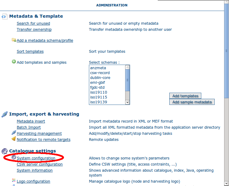
The link to the System configuration page
Clicking the link bring up the system configuration menu. A detailed description of these parameters follows.
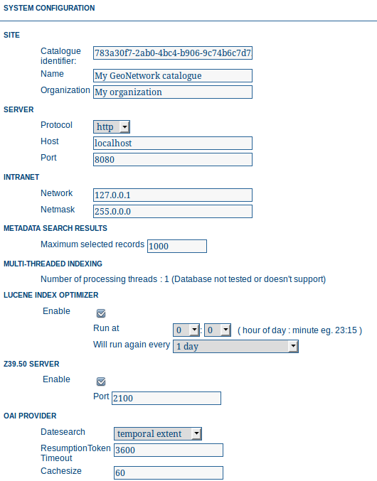
The configuration options - part 1
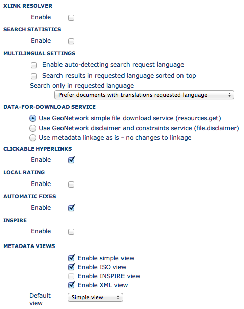
The configuration options - part 2
The configuration options - part 3
Note: at the bottom of the page (you will need to scroll down) there are three buttons with the following purpose:
- Back Simply returns to the main administration page, ignoring any changes you may have made.
- Save Saves the current options. If some options are invalid, the system will show a dialogue with the wrong parameter and will focus its text field on the page. Once the configuration is saved a success dialogue will be shown.
- Refresh Reads the settings from the database again and refreshes the options with those values.
Site parameters
Catalogue identifier A universally unique identifier (uuid) that distinguishes your catalogue from any other catalogue. This a unique identifier for your catalogue and its best to leave it as a uuid.
Name The name of the GeoNetwork node. Information that helps identify the catalogue to a human user.
Organization The organization the node belongs to. Again, this is information that helps identify the catalogue to a human user.
Server parameters
Here you have to enter the details of the web address of your GeoNetwork node. This address is important because it will be used to build addresses that access services and data on the GeoNetwork node. In particular:
- building links to data file uploaded with a metadata record in the editor.
- when the OGC CSW server is asked to describe its capabilities. The GetCapabilities operation returns an XML document with HTTP links to the CSW services provided by the server. These links are dynamically built using the host and port values.
Protocol The HTTP protocol used to access the server. Choosing http means that all communication with GeoNetwork will be visible to anyone listening to the protocol. Since this includes usernames and passwords this is not secure. Choosing https means that all communication with GeoNetwork will be encrypted and thus much harder for a listener to decode.
Host The node’s address or IP number. If your node is publicly accessible from the Internet, you have to use the domain name. If your node is hidden inside your private network and you have a firewall or web server that redirects incoming requests to the node, you have to enter the public address of the firewall or web server. A typical configuration is to have an Apache web server on address A that is publicly accessible and redirects the requests to a Tomcat server on a private address B. In this case you have to enter A in the host parameter.
Port The node’s port (usually 80 or 8080). If the node is hidden, you have to enter the port on the public firewall or web server.
Intranet Parameters
A common need for an organisation is to automatically discriminate between anonymous internal users that access the node from within an organisation (Intranet) and anonymous external users from the Internet. GeoNetwork defines anonymous users from inside the organisation as belonging to the group Intranet, while anonymous users from outside the organisation are defined by the group All. To automatically distinguish users that belong to the Intranet group you need to tell GeoNetwork the intranet IP address and netmask.
Network The intranet address in IP form (eg. 147.109.100.0).
Netmask The intranet netmask (eg. 255.255.255.0).
Metadata Search Results
Configuration settings in this group determine what the limits are on user interaction with the search results.
Maximum Selected Records The maximum number of search results that a user can select and process with the batch operations eg. Set Privileges, Categories etc.
Multi-Threaded Indexing
Configuration settings in this group determine how many processor threads are allocated to indexing tasks in GeoNetwork. If your machine has many processor cores, you can now determine how many to allocate to GeoNetwork indexing tasks. This can bring dramatic speed improvements on large indexing tasks (eg. changing the privileges on 20,000 records) because GeoNetwork can split the indexing task into a number of pieces and assign them to different processor cores.
Number of processing threads The maximum number of processing threads that can be allocated to an indexing task.
Note: this option is only available for databases that have been tested. Those databases are PostGIS and Oracle. You should also carefully consider how many connections to the database you allocate in the database configuration as each thread could tie up one database connection for the duration of a long indexing session (for example). See Advanced configuration for more details of how to configure the number of connections in the database connection pool.
Lucene Index Optimizer
Configuration settings in this group determine when the Lucene Index Optimizer is run. By default, this takes place at midnight each day. With recent upgrades to Lucene, particularly Lucene 3.6.1, the optimizer is becoming less useful, so this configuration group will very likely be removed in future versions.
Z39.50 configuration
GeoNetwork can act as a Z39.50 server. Z39.50 is the name of an older communication protocol used for distributed searching across metadata catalogs.
Enable: Check this option to enable the Z39.50 server, uncheck it to disable the Z39.50 server.
Port: This is the port on which GeoNetwork will be listening for incoming Z39.50 requests. Z3950 servers can run on any port, but 210 (not recommended), 2100 and 6668 are common choices. If you have multiple GeoNetwork nodes running on the same machine then you need to make sure each one has a different port number.
GeoNetwork must be restarted to put any changes to these values into use.
OAI Provider
Options in this group control the way in which the OAI Server in GeoNetwork responds to OAIPMH harvest requests from remote sites.
Datesearch: OAI Harvesters may request records from GeoNetwork in a date range. GeoNetwork can use one of two date fields from the metadata to check for a match with this date range. The default choice is Temporal extent, which is the temporal extent from the metadata record. The other option, Modification date, uses the modification date of the metadata record in the GeoNetwork database. The modification date is the last time the metadata record was updated in or harvested by GeoNetwork.
Resumption Token Timeout: Metadata records that match an OAI harvest search request are usually returned to the harvester in groups with a fixed size (eg. in groups of 10 records). With each group a resumption token is included so that the harvester can request the next group of records. The resumption token timeout is the time (in seconds) that GeoNetwork OAI server will wait for a resumption token to be used. If the timeout is exceeded GeoNetwork OAI server will drop the search results and refuse to recognize the resumption token. The aim of this feature is to ensure that resources in the GeoNetwork OAI server are released.
Cache size: The maximum number of concurrent OAI harvests that the GeoNetwork OAI server can support.
GeoNetwork must be restarted to put any changes to the resumption token timeout and the Datesearch options into use.
XLink resolver
The XLink resolver replaces the content of elements with an attribute @xlink:href (except for srv:operatesOn element) with the content obtained from the URL content of @xlink:href. The XLink resolver should be enabled if you want to harvest metadata fragments or reuse fragments of metadata in your metadata records.
Enable: Enables/disables the XLink resolver.
Note: to improve performance GeoNetwork will cache content that is not in the local catalog.
Search Statistics
Enables/disables search statistics capture. Search statistics are stored in the database and can be queried using the Search Statistics interface on the Administration page. There is very little compute overhead involved in storing search statistics as they are written to the database in a background thread. However database storage for a very busy site must be carefully planned.
Multilingual Settings
Options in this group determine how GeoNetwork will search metadata in multiple languages.
Enable auto-detecting search request language: If this option is selected, Geonetwork will analyse the search query and attempt to detect the language that is used before defaulting to the GUI language.
Search results in requested language sorted on top: If this option is selected, a sort clause will be added to each query to ensure that results in the current language are always sorted on top. This is different from increasing priority of the language in that it overrides the relevance of the result. For example, if a german result has very high relevance but the search language is french then the french results will all come before the german result.
Search only in requested language The options in this section determines how documents are sorted/prioritised relative to the language in the document compared to the search language.
- All documents in all languages (No preferences) - The search language is ignored and will have no effect on the ordering of the results
- Prefer documents with translations requested language - Documents with a translation in the search language (anywhere in the document) will be prioritized over documents without any elements in the search language
- Prefer documents whose language is the requested language - Documents that are the same language as the search language (ie. the documents that are specified as being in the same language as the search language) are prioritized over documents that are not.
- Translations in requested language - The search results will only contain documents that have some translations in the search language.
- Document language is the requested language - The search results will contain documents whose metadata language is specified as being the in search language
Data-For-Download Service
GeoNetwork editor supports uploading one or more files that can be stored with the metadata record. When such a record is displayed in the search results, a ‘Download’ button is provided which will allow the user to select which file they want to download. This option group determines how that download will occur.
Use GeoNetwork simple file download service: Clicking on any file stored with the metadata record will deliver that file directly to the user via the browser.
Use GeoNetwork disclaimer and constraints service: Clicking on any file stored with the metadata record will deliver a zip archive to the user (via the browser) that contains the data file, the metadata record itself and a summary of the resource constraint metadata as an html document. In addition, the user will need to provide some details (name, organisation, email and optional comment) and view the resource constraints before they can download the zip archive.
Clickable hyperlinks
Enables/disables hyperlinks in metadata content. If a URL is present in the metadata content, GeoNetwork will detect this and make it into a clickable hyperlink when it displays the metadata content.
Local rating
Enables/disables local rating of metadata records.
Automatic fixes
For each metadata schema, GeoNetwork has an XSLT that it can apply to a metadata record belonging to that schema. This XSLT is called update-fixed-info.xsl and the aim of this XSLT is to allow fixed schema, site and GeoNetwork information to be applied to a metadata record every time the metadata record is saved in the editor. As an example, GeoNetwork uses this XSLT to build and store the URL of any files uploaded and stored with the metadata record in the editor.
Enable: Enabled by default. It is recommended you do not use the GeoNetwork default or advanced editor when auto-fixing is disabled. See http://trac.osgeo.org/geonetwork/ticket/368 for more details.
INSPIRE
Enables/disables the INSPIRE search options in advanced search panel.
Metadata Views
Options in this section enable/disable metadata element groups in the metadata editor/viewer.
Enable simple view: The simple view in the metadata editor/viewer: - removes much of the hierarchy from nested metadata records (such as ISO19115/19139) - will not let the user add metadata elements that are not already in the metadata record It is intended to provide a flat, simple view of the metadata record. A disadvantage of the simple view is that some of the context information supplied by the nesting in the metadata record is lost. Enable ISO view: The ISO19115/19139 metadata standard defines three groups of elements: - Minimum: those elements that are mandatory - Core: the elements that should be present in any metadata record describing a geographic dataset - All: all the elements Enable INSPIRE view: Enables the metadata element groups defined in the EU INSPIRE directive. Enable XML view: This is a raw text edit view of the XML record. You can disable this if (for example), you don’t want inexperienced users to be confused by the XML presentation provided by this view.
Metadata Privileges
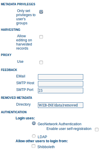
Only set privileges to user’s groups: If enabled then only the groups that the user belongs to will be displayed in the metadata privileges page (unless the user is an Administrator). At the moment this option cannot be disabled and is likely to be deprecated in the next version of GeoNetwork.
Harvesting
Allow editing on harvested records: Enables/Disables editing of harvested records in the catalogue. By default, harvested records cannot be edited.
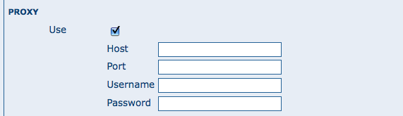
Proxy
For some functions (eg. harvesting) GeoNetwork must be able to connect to remote sites. This may not be possible if an organisation uses proxy servers. If your organisation uses a proxy server then GeoNetwork must be configured to use the proxy server in order to correctly route outgoing requests to remote sites.
Use: Checking this box will display the proxy configuration options panel.
The proxy configuration options
Host: The proxy server name or address to use (usually an IP address).
Port: The proxy server port to use.
Username (optional): a username should be provided if the proxy server requires authentication.
Password (optional): a password should be provided if the proxy server requires authentication.
Feedback
- GeoNetwork needs to send email if:
- you are using the User Self-registration system or the Metadata Status workflow
- a file uploaded with a metadata record is downloaded
- a user provides feedback using the online form.
You have to configure the mail server GeoNetwork should use in order to enable it to send these emails.
Email: This is the email address that will be used to send the email (the From address).
SMTP host: the mail server address to use when sending email.
SMTP port: the mail server SMTP port (usually 25).
Removed metadata
Defines the directory used to store a backup of metadata and data after a delete action. This directory is used as a backup directory to allow system administrators to recover metadata and possibly related data after erroneous deletion. By default the removed directory is created in the GeoNetwork data folder.
Authentication
In this section you define the source against which GeoNetwork will authenticate users and passwords.
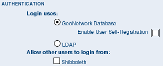
Authentication configuration options
By default, users are authenticated against info held in the GeoNetwork database. When the GeoNetwork database is used as the authentication source, the user self-registration function can be enabled. A later section discusses user self-registration and the configuration options it requires.
You may choose to authenticate logins against either the GeoNetwork database tables or LDAP (the lightweight directory access protocol) but not both. The next section describes how to authenticate against LDAP.
In addition to either of these options, you may also configure other authentication sources. At present, Shibboleth is the only additional authentication source that can be configured. Shibboleth is typically used for national access federations such as the Australian Access Federation. Configuring shibboleth authentication in GeoNetwork to use such a federation would allow not only users from a local database or LDAP directory to use your installation, but any user from such a federation.
LDAP Authentication
The section defines how to connect to an LDAP authentication system.
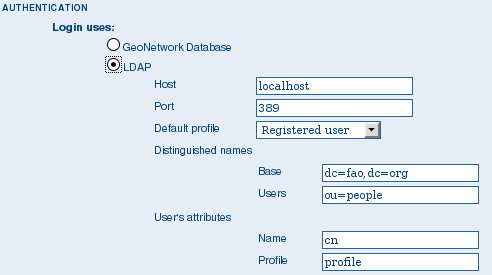
The LDAP configuration options
Typically all users must have their details in the LDAP directory to login to GeoNetwork. However if a user is added to the GeoNetwork database with the Administrator profile then they will be able to login without their details being present in the LDAP directory.
Shibboleth Authentication
When using either the GeoNetwork database or LDAP for authentication, you can also configure shibboleth to allow authentication against access federations.
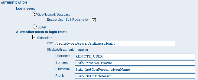
The Shibboleth configuration options
Shibboleth authentication requires interaction with Apache web server. In particular, the apache web server must be configured to require Shibboleth authentication to access the path entered in the configuration. The apache web server configuration will contain the details of the shibboleth server that works out where a user is located (sometimes called a ‘where are you from’ server).
The remainder of the shibboleth login configuration describes how shibboleth authentication attributes are mapped to GeoNetwork user database fields as once a user is authenticated against shibboleth, their details are copied to the local GeoNetwork database.
Configuring OGC Catalogue Services Web (CSW)
Configuring User Self-Registration
GeoNetwork has a self-registration function which allows a user to request a login which provides access to ‘registered-user’ functions. By default this capability is switched off. To configure this capability you must complete the following sections in the ‘System configuration’ menu:
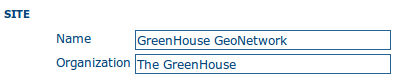
- configure the site name and organization name as these will be used in emails from this GeoNetwork site to newly registered users. An example of how to config these fields at the top of the system configuration form is:
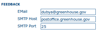
- configure feedback email address, SMTP host and SMTP port. The feedback email address will be sent an email when a new user registers and requests a profile other than ‘Registered User’. An example of how to config these fields in the system configuration form is:
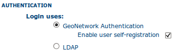
- check the box, enable user self-registration in the Authentication section of the system configuration form as follows:
When you save the system configuration form, return to the home page and log out as admin, your banner menu should now include two new options, ‘Forgot your password?’ and ‘Register’ (or their translations into your selected language) as follows:

You should also configure the xml file that includes contact details to be displayed when an error occurs in the registration process. This file is localized - the english version is located in INSTALL_DIR/web/geonetwork/loc/en/xml/registration-sent.xml.
Finally, if you want to change the content of the email that contains registration details for new users, you should modify INSTALL_DIR/web/geonetwork/xsl/registration-pwd-email.xsl.